How Barcelona is designed?
https://barcelona365.info/wp-content/themes/osmosis/images/empty/thumbnail.jpg 150 150 Barcelona365 Barcelona365 https://barcelona365.info/wp-content/themes/osmosis/images/empty/thumbnail.jpgWhen we travel to a new place, one of the first things that we should do is to understand how the city is designed; it will help us to orientate in this place and to understand the history of this place.
So, How Barcelona is designed?
Lets see the map of Barcelona to understand it better.
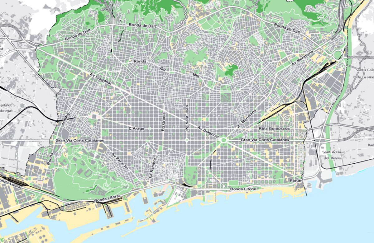
Limits / borders of Barcelona:
First at all, you will see that Barcelona is like a big rectangle with 4 sides: at the bottom we have the sea; parallel to it, at the back of the city, you will see a green area: it’s a mountain in line call Collcerola with the pic call Tibidabo; at the right side of the rectangle we have a river call Besos (you will recognize it in the map with a green curve; and at the left side we have another river call Llobregat (this river is out of the printed map because really there is another town between the city and the left river call Hospitalet.
But please to understand Barcelona imagine Barcelona and Hospitalet as a unique area: so sea, mountain, and two rivers.
By the way, beyond the left river (the Llobregat) the Airport of Barcelona is located.
Now let’s identify the parts of the city:
- Old Town: You will see that there is a part, close to the sea, surrounding an Avenue call “La Rambla”. The streets of this area are like a maze (please find this small area in the map). Well, that was exactly Barcelona until 170 years ago (the half of the nineteen century). This is the Old Town.
The city was founded by romans the year 12 BC but until 170 years ago the city was only this. At the limit of this maze, even you will recognize were we had the Medieval Walls. - New Town: Out of this maze, surrounding it, you will see that the design of the streets is a grid (I like to say like a big chess game board). This is the New city. The city built in the late nineteenth and early twentieth Century (in special the part that surround an Avenue that you will find in the map with the name: Pg Gracia (Passeig de Gràcia)).
When finally it was possible to knock down the walls (it was a punishment of the King), the council organized a contest to choose the best way to design the new extension of the city; the lands that separated the Old Town from other villages. After long discussions, it was chosen the plane of the engineer Idelfons Cerda, he, very rationalist, design an utopic city with parallel and vertical streets to the sea: a big grid.
We call it “L’Eixample”, the enlargement in catalane language. It’s the biggest neighborhood of Barcelona! - At the Upper side of Barcelona you will recognize that the city become a maze again. This part is the result of these old villages that weren’t Barcelona until the end of the eighteenth Century, when they were integrated to the city.
One of the most popular of these neighborhoods is Gracia, right at the upper side of Passeig de Gràcia, but there are others: Sants, Sarrià, etc. - The Montjuic Hill: to complete the map we should identify another big green area in front of the sea. This is the Montjuic Hill, a big park in town.
Fortunately Idelfons Cerdà, who designs l’Eixample, thought to leave the hill as a big garden for the city. We can imagine that this hill with great panoramic views over the sea and the city would be very requested for healthy families to live, but fortunately it finishes to be a big garden for every Barcelonese, there we have the Olympic facilities, museums, a castle, etc., but no once is leaving there.
By the way, in front of the hill, the Cruise Ship Terminal is located.
There are thousand of smalls details to discover once you put your foot in Barcelona but this description will help you to keep an easy map in your mind about the city.
Please, if you have any doubt about the map, ask it directly here, because frequently it is the same doubt that others will have when they check the map.